Artificial Intelligence for Water Cycle
Current situation – Today, satellite remote sensing can measure nearly all the major flows in the water cycle. This includes precipitation, evaporation, and changes water stored underground and in lakes and reservoirs. These flows are related to one another: the flows into and out of any region should be balanced. However, so far, uncertainties and errors in EO datasets do not allow obtaining a balanced water budget with satellite data. This shows that improvements are needed. We used in the past a method called Optimal Interpolation (OI) to optimize satellite datasets, so that they better balance the water budget. However, this method only works at the scale of basins, and only when discharge measurements are available, which is actually rare at the global scale.
Using Machine learning to optimize EO datasets – To extend our findings to the pixel scale and all around the world, we created a statistical model based on machine learning (i.e. a Neural Network, NN) and aiming at optimizing the EO datasets monitoring the water cycle. This model is trained on the OI results, where available. To bene t from the experience acquired on the OI, several features have been imposed to the NN model, embedded directly inside the NN architecture or in the learning process:
- Calibration modules to transform independently each one of the EO datasets towards a better water budget;
- Mixing models to combine several EO datasets for a same water component;
- Closure constraint;
- Or stabilizers to avoid departing from physical values for the water components.
These features aiming at introducing physical a priori knowledge of the problem into the NN are very innovative because most NN applications do not investigate what is actually done inside the NN itself, only the outputs are generally controlled. This is a regularization of the NN modeling, doing structural stabilization (constraining the NN architecture) and learning regularization. The paper Aires and Pellet (2024) (Chapter 1 in Part II) is under review at the Journal of Hydrology.
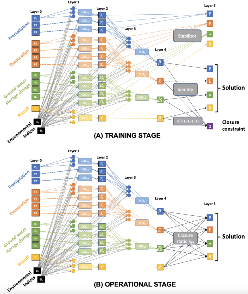
Figure: Neural network scheme for the training (A) and the operational (B) stages.
Better monitoring of the water cycle at the global scale – The NN model can make predictions at the pixel scale over most of the Earth’s land surfaces. For that purpose, about 2000 river discharges estimates were used to represent the diversity of hydrologic conditions. The water budget is improved after our optimization of the water component estimates. When compared to in situ observations, our optimization can often improve satellite observations. Furthermore, our water cycle analysis indicates when and where EO dataset corrections are most needed, which provides useful information to the data producers. The paper Heberger et al. 2014 (Chapter 2 in Part III) presents our water cycle analysis at the global scale.
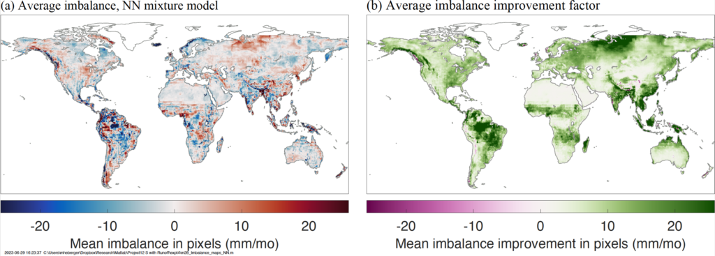
Figure: Water cycle budget imbalance after our optimization of the EO datasets (a)-Left and improvement factor (b)-Right.
Correction of the evapotranspiration datasets – On our global water cycle analysis, it was clear that Evapotranspiration is one of the components of the water cycle that has large errors. In fact, E is not estimated using a direct satellite observation, but indirect data (soil moisture, surface temperature) are used in a schematic model to estimate E. We proposed in Hascoet et al. (2014) (Chapter 3 in Part III) a correction of the major Evapotranspiration datasets, so that this component is more coherent with the other water components such as the precipitation, ground water storage change and river discharges. To correct systematic regional biases present in the EO datasets of E, only a seasonality but pixel-wise transformation is proposed. After this correction of E, again, the water budget imbalance is reduced and proximity to in situ data is not degraded.
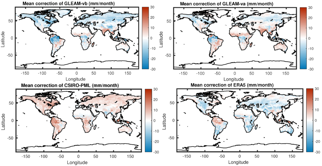
Figure: Corrections applied to four evapotranspiration datasets
Publication list related to this project:
- Aires, Pellet, Synergizing AI and Physical Expertise to Close the Water Budget from Satellite Data, J. of Hydrology, in review, 2024.
- Heberger, Aires, Pellet, Improving Satellite Remote Sensing Estimates of the Global Terrestrial Hydrologic Cycle via Neural Network Modeling, submitted, 2023.
- Hascoet, Pellet, Aires, Learning global evapotranspiration dataset corrections from a water cycle closure supervision, Remote Sensing, Remote Sens. 2024, 16(1), 170, https://doi.org/10.3390/rs16010170.
Availability of codes and data:
We provide public access to the geophysical datasets and the codes:
- Input database of hydrologic earth observations (NetCDF)
- Matlab scripts that de ne the neural network architecture (Matlab scripts)
- Matlab code for evaluating model performance (Matlab scripts)
- Output database of global and pixel-scale corrected EOs (NetCDF)
generated during the contract. They can be obtained under request to victor.pellet@estellus.fr includes: